15 Dec 2017
In November, Amanda made a presentation at ‘The Impact of Rapid Urbanisation on Health in Chinese Mega-Cities’ workshop held in Xiamen. This workshop aimed to build collaboration and knowledge-sharing between 55 researchers from the UK and China. It was funded under the Researcher Links scheme offered within the Newton Fund, the British Council and National Natural Science Foundation of China (NSFC), and was organized by Cardiff University and the Institute of Urban Environment (Chinese Academy of Sciences).
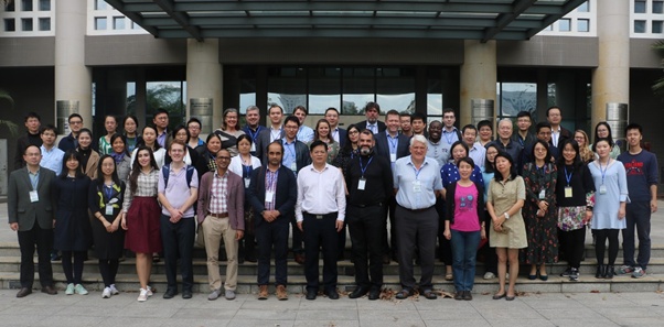
We had keynote speeches by Professor Yongguan Zhu (Director of the Institute of Urban Environment) on ‘Chinese Perspectives of Urbanisation and Human Health’, and by Professor Terry Marsden (Director of Sustainable Places Research Institute at Cardiff University) on ‘Place-based Methods in Sustainability Science.’ Examples of presentation topics included: rural-urban migration, transport (walking, high speed rail), and air pollution (CO2, haze governance, public health, biomass burning).
For the LUCAS case study on Shanghai, this topic is important to consider Shanghai’s size and location in a mega-city region. Zhao et al. (2006) conducted a study of Shanghai from 1975-2005 and found that as a result of urbanisation, air and water pollution has increased, the average air temperature has risen – creating a heat island effect, and there has been a loss of biodiversity and agricultural land. Further, the rapid pace of this change has implications for China’s institutions (Ren 2013). These characteristics of urbanisation then have crucial insights to developing policy solutions to environmental issues in China.
10 Nov 2017
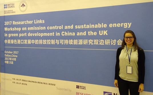
In October, Amanda made a presentation at the ‘Emission Control and Sustainable Energy in Green Port Development’ workshop held in Dalian. This workshop aimed to build collaboration and knowledge-sharing between researchers in the UK and China. It was funded under the Researcher Links scheme offered within the Newton Fund, the British Council and National Natural Science Foundation of China (NSFC), and was organized by Liverpool University and Dalian University.
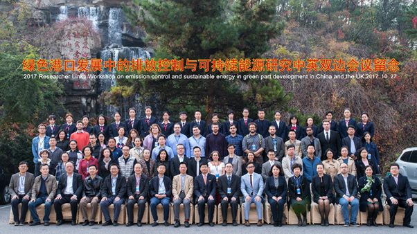
The goal of the workshop was to discuss research on methods to reduce port emissions and different strategies of green port development. We were welcomed by the President of Dalian University and heard presentations on green development, emissions management, and energy management.
For the LUCAS group and our Shanghai case study, the port is an interesting consideration given that it is one of the world’s largest and busiest ports. Current policies testify to the tension between the economy and the environment: Shanghai’s port is an important economic growth asset; however, Song’s 2014 research has shown the emissions social cost of the Yangshan port totals 287 million USD (in 2009). While this port has expansion plans for 2020, the government also developed environmental goals for this year which seek to reduce energy consumption per handling capacity unit by 7 percent in 2017 (compared to 2010 levels). The strategy to achieve this goal includes six sets of shore power facilities, replacing energy sources, and increasing marine oil standards.
Given that ports co-evolve with cities in general (see Hall and Jacobs 2012), their international activities and operations will remain an important factor for assessing sustainability in cities.
24 Oct 2017
LUCAS’ Ben Purvis recently attended the ERC GeoDiverCity International Workshop on “Theories and models of urbanization” at the Institut des Systèmes Complexes in Paris. The workshop brought together academics from a variety of disciplines such as physics, computer science, economics, and geography to engage in discussions relating to urban theories and modelling. Keynotes included talks from Michael Batty, Elsa Arcaute, Fulong Wu, and Michael Storper.
Much of the discussion was focused around hypotheses of scaling laws for urban systems. These ‘laws’ follow from Kleiber’s observation in the 1940s that the metabolic rate of various animals seems to scale with their body mass with an exponent of ¾, i.e. a log-log plot of the two parameters produces a straight line with gradient ¾, as shown in the diagram below. With parallels drawn between urban systems and living organisms, it was natural that urban theory literature would arise considering the scaling of city size with various urban attributes. A key example of this is presented by Bettencourt et al in 2007, with examples of a diverse range of parameters such as new patents, GDP, serious crimes, and length of electrical cables.
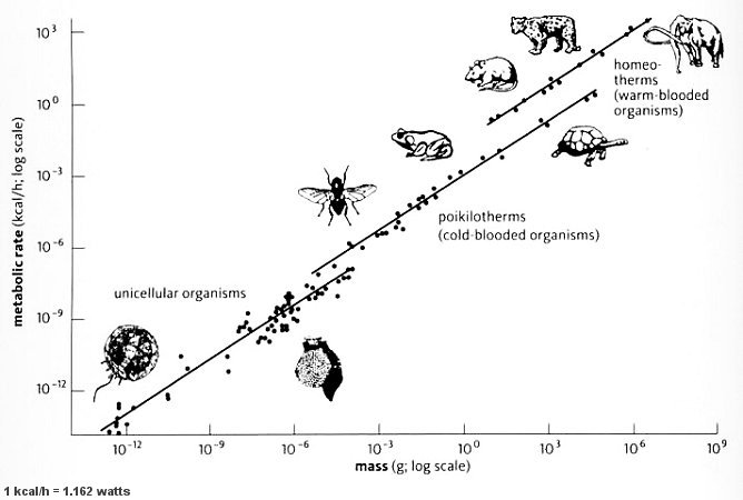
Kleiber’s Law, taken from https://universe-review.ca/R10-35-metabolic.htm
These so called scaling laws remain controversial however, Batty explained that whilst there appeared to be a strong correlation, with a non-linear exponent, in rank-size for the largest cities in the US, this correlation became weaker on the inclusion of the not dissimilar cities of Canada. In her keynote, Arcaute presented work that investigated the somewhat arbitrarily defined boundaries of cities, and how changing this definition based upon population density affected the exponent of various scaling laws. This work is presented in a 2016 paper, and provides evidence that urban scaling values are sensitive to the definition of the city.
A recent paper by Leitão et al (2016) argues that least-square fitting is insufficient to conclude the existence of non-linear scaling, presented methodology to better investigate data fluctuations. The existence of non-linear scaling laws was also questioned in a keynote by Marc Barthelemy, who cautions oversimplification of complex reality. Storper too highlighted how they can be useful, but present ‘ever diminishing scientific returns’, as well as arguing how it is problematic to average over huge datasets over many diverse regions and historic time periods.
This contention around the existence of scaling laws seems to lead to more fundamental epistemological questions. Foremost whether universal ‘laws’ that govern the properties of such complex systems as cities exist to be discovered, and whether the pursuit of some sort of ‘unified urban theory’ is misguided. Further there can often be conflation between understanding a system and being able to make predictions, the latter does not necessarily follow the former. Another epistemological conflict arose surrounding ‘measuring of the immeasurable’ and the differences between the quantitative approaches that tend to be taken by physical scientists and the more qualitative interpretative approaches taken within the social sciences.
The value of interdisciplinarity when facing the differing epistemological approaches taken primarily between the physical and social sciences was an underlying subcurrent of the conference. The assumption that there is such a thing as getting the urban system ‘right’ in terms of its physical form was probed by Storper. Disciplinary conflicts were also explored by Lena Sanders, and Isabelle Thomas, who presented the metaphor of ‘lions and butterflies’ for the relation between economists and geographers. Economists being ‘lions’, bound by the rules of the pride, and likely to devour the unwitting economic geographer who attempts to tame them, whereas geographers are more like butterflies freely flying the fields of knowledge and tasting the best of every flower they visit. The stark lack of dialogue between the two fields was explored, backed up with bibliometric work on cross-disciplinary citations. Storper argued the success of economists to produce models of human behaviour (the veracity of these models being immaterial) gives them an edge over the more individualistic qualitative approaches taken by geographers within the broader academic environment.
Perhaps the take home message was, as Michael Storper put it, the importance of being aware and self-critical of one’s own methodological individualism, and it seems this ability may be enriched by discussing different epistemological assumptions in an interdisciplinary environment.
13 Oct 2017
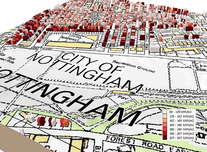
A summary of the InSmart project completed by Gavin Long and Darren Robinson has been published as a GeoPlace case study. The work describes the development of a virtual energy model of Nottingham’s building stock, through integration of the Local Land and Property Gazetteer data found within GeoPlace’s AddressBase products.
Simulating the energy use of buildings in the City of Nottingham - The InSmart project
21 Aug 2017
Written by Julian Rosser
On the Sustaining Urban Habitats project, part of our work is focused on predicting building energy use so that measures for reducing energy demand may be effectively targeted. Simulation requires representative 3D city models of urban areas so that accurate estimates of energy demand imposed on the city can be made.
Over the last years, 3D city models have become increasingly common. CityGML has emerged as a standardised representation of the shape and features that make up urban areas. This Open Geospatial Consortium standard uses the concept of Levels of Detail to categorise the complexity and amount of information present in the urban scene. The classification reflects both the geometry and semantics of the objects contained within the model.
Example CityGML 3D model view at Levels of Detail 1 -4 (needs HTML5)
Fullscreen model viewer
Despite steady improvements in aerial surveying procedures creating 3D data (e.g. LiDAR, photogrammetry), many applications still start with 2D geospatial data as a base (e.g. either OpenStreetMap or map data from a national provider, like Ordnance Survey). The building footprints are then transformed, perhaps using an extrusion, geometric modelling (such as a triangulation) or procedural modelling, to add in 3D detail. To create CityGML models at LOD2 or above, these buildings models then must be processed such that particular components are correctly attributed e.g. as RoofSurface, GroundSurface and WallSurfaces. At LODs 3 and 4, components such as windows, doors and rooms may be included.
Application Domain Extensions (ADE) allow additional domain specific details to be added to the model. In the case of energy modelling and simulation, the EnergyADE produced by SIG3D is particularly relevant. This allows for inclusion of attributes on energy efficiency, thermal properties, construction materials and so forth. Example CityGML and EnergyADE models can be found on the web, however, relatively few for the UK are readily available. As such we’ve created some sample models of our office building using OpenStreetMap and UK Environment Agency open LiDAR at LOD2, and mapped in some EnergyADE attributes according to the v0.6 schema.
Sample CityGML building
Sample CityGML building with EnergyADE attributes